 PT
PT
 ES
ES
 EN
EN
Não conseguimos encontrar a internet
Tentando reconectar
Algo deu errado!
Aguarde enquanto voltamos ao normal
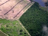
Use of Formosat-2 satellite imagery to detect near real time deforestation in Amazonia
26/06/12
Compartilhar:


Não conseguimos encontrar a internet
Tentando reconectar
Algo deu errado!
Aguarde enquanto voltamos ao normal
Compartilhar: