All of this information has been disseminated in monthly bulletins with wide repercussions in the regional and national media. In addition, the maps generated are made available for interactive consultations at the Imazon portal for geographic information, ImazonGeo 2.0 ( www.imazongeo.org.br ).
To increase efficiency in assigning liability to environmental violators, the program carries out a series of activities related to environmental law, including: analysis of the performance of administrative and judicial proceedings against environmental crimes; promotion of transparency regarding the situation of environmental proceedings against environmental infractions in Protected Areas in the Amazon; dissemination of the results to law professionals (prosecutors, attorneys general, police chiefs, judges, environmental analysts), members of the legislative branch and civil society; and analysis of the performance of policies for combating illegal deforestation considering factors of environmental policy (i.e. enforcement and levying fines) and the market (i.e. prices for agricultural products).
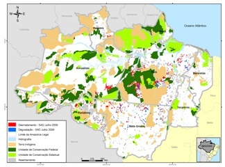
This post was published on 27 de August de 2013
Forest degradation caused by burning and logging increased nearly fivefold in September From January…
An area equivalent to the city of São Paulo had irregular logging in just one…
Devastated area hit 303 km² in the month, the second consecutive growth this year …
Called PrevisIA, the tool shows the forest areas under the greatest threat of deforestation to…
Forest destruction reached 10,362 km² last year, the largest area since the beginning of Imazon’s…
This devastated area is 31% higher than in the same period in 2020, according to…