Governments worldwide are currently preparing for REDD implementation. Clark Labs, Imazon and CI provided training in Suriname on the application of spatial modeling for estimating emissions baselines at the site, provincial and national level. This included its use for the assessment of the impacts of national policies and carbon prices on incentives for participation in REDD, as explored through the OSIRIS tool developed by CI (www.conservation.org/osiris). The training also reviewed how modeling must be used to apply the methodologies proposed to the Voluntary Carbon Standards Group (www.v-c-s.org).
The technical issues of REDD–carbon accounting, additionality, baseline or “business as usual,” leakage and permanence—are complex and require sophisticated tools. Currently, IDRISI Selva and its Land Change Modeler (LCM), developed by Clark Labs in cooperation with Conservation International, is the only integrated modeling solution to address many of these requirements of REDD projects.
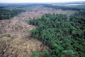
Clark Labs and Imazon produced a GIS data set on spatial data related to drivers of deforestation, including, but not limited to, variables of access (i.e., road distance), markets (i.e., town distance, cost distance to markets), and physical parameters (i.e., elevation, soil type).
Using forest deforestation data, Clark Labs and Imazon produced a set of four spatial models of the most probable deforestation in a “non-REDD scenario” for the next 30 years in five-year intervals. This included a map of deforestation potential and maps of predicted deforestation patterns for each five-year period. Each model had unique specifications provided by CI and the Surinamese government. These combined two different rates of total deforestation over the 30-year period, and two different sets of assumptions of infrastructure development.
The spatial modeling of such outcomes, or reference scenarios, is critical for the consideration of REDD implementation. IDRISI Selva’s Land Change Modeler provides for the development of reference scenarios, utilizing probability functions, and allows for the incorporation of the varied types of information and data which may impact the rate and quantity of deforestation change. Drivers of change are often of geographic character, such as the slope of the land or proximity to other areas of deforestation, but social and economic drivers, as well as the particular context of governmental policy frameworks, must also be considered. This workshop increased the capacity of technical analysts, working in national and provincial agencies, to explore possible outcomes of different policies and incentive systems.
Clark Labs and Imazon’s one-week training was based on previous capacity building trainings conducted in Suriname by Clark Labs. Using a set of models already produced, participants were shown the process of running the LCM models in IDRISI and the basis for defining the criteria in the four models. After this, the participants worked with Clark Labs and Imazon to re-define criteria according to best estimates of realistic government policies on land use. This information will be incorporated to refine the four models created during the workshop.
“Suriname is instrumental in engaging Suriname’s civil society in the concepts of sustainable development. Encompassing many ministries, the trainees are now fully versed on spatial modeling techniques for the development of future scenarios,” stated Clark Labs Chief Applications Research Officer Stefano Crema.
Annette Tjonsiefat, Executive Director of Conservation International Suriname, said, “The training provided us with important knowledge and skills for spatial planning, which will be indispensable to help the government of Suriname achieve its sustainable development goals.” Clark Labs Chief Applications Research Officer Stefano Crema maintained, “Encompassing many ministries, the trainees are now fully versed on spatial modeling techniques for the development of future scenarios.”
Clark Labs and CI’s Science and Knowledge Division (formerly the Center for Applied Biodiversity Science) share a long-standing collaborative relationship in the testing, application and improvement of spatial modeling tools for REDD projects.
This post was published on 26 de March de 2013
Forest degradation caused by burning and logging increased nearly fivefold in September From January…
An area equivalent to the city of São Paulo had irregular logging in just one…
Devastated area hit 303 km² in the month, the second consecutive growth this year …
Called PrevisIA, the tool shows the forest areas under the greatest threat of deforestation to…
Forest destruction reached 10,362 km² last year, the largest area since the beginning of Imazon’s…
This devastated area is 31% higher than in the same period in 2020, according to…