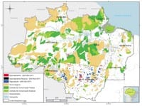
 Check the data on deforestation and forest degradation in the Amazon in June 2012.
Martins, H., Fonseca, A., Souza Jr., C., Sales, M., & Veríssimo, A. (2012). Forest Transparency for the Brazilian Amazon (June 2012) (p. 13). Belém.
In June 2012, the Sistema de Alerta de Desmatamento (SAD – Deforestation Alert System) has detected 34,5 square km of deforestation in the Legal Amazon. This represented a 66% decrease in CO2 equivalents totaledcommittedto100.5squarekm. Duetothe cloud cover, it was possible to monitor only 73% of the territory, a value greater than June 2011 (65%). The accumulated deforestation from August 2011 to June 2012 totaled 907 square km. There was a reduction of 41% over the previous period (August 2010 to June 2011) when deforestation totaled 1,534 square kilometers.
In June 2012, 60% of the deforestation occurred in Pará. Then appears the Amazon with 28%.
The remainder (12%) occurred in Rondônia (6%) and Mato Grosso (6%). The degraded forests in the Amazon amounted to only 14,5 square kilometers in June 2012. Compared to June 2011, when forest degradation totaled 193 square km, there was a reduction of 93%. Most (45%) of this degradation occurred in Mato Grosso.
The forest degradation accumulated in the period (August 2011 to June 2012) reached 1,974 square kilometers. In the previous period (August 2010 to June 2011), when degradation amounted to 6,274 square kilometers, a reduction of 69%.
In June 2012, the deforestation detected by SAD pledged 960,000 km of CO2 equivalent. Accumulated in the period (August 2011 to June 2012) emissions compared to June 2011 when
Deforestation Statistics
According to SAD, deforestation (total suppression of forest to other alternative land uses) reached 34,5 square kilometers in June 2012 (Figure
deforestation totaled 74 million tons, representing a reduction of 18% over the previous period (August 2010 to June 2011.)
Google SAD-EE
In June the detection of deforestation and forest degradation of the SAD was performed on the platform of Google Earth Engine. This system was developed in collaboration with Google and use the same process already used by the SAD, with reflectance images of MODIS to generate alerts from deforestation and forest degradation. Called SAD-EE (Earth Engine), the new platform will provide the data and tools for processing of satellite images, editing digital maps and mapping validation that run on Google’s cloud of computers.
This will reduce the time for preprocessing, analysis and dissemination of data and may even reach 50% of the time to generate alerts, giving greater flexibility in information processing and enabling the detection of deforestation in areas beyond the borders of the Brazilian Amazon because all these technologies and satellite data will be available to institutions in other countries, enabling monitoring on a global scale.
Download the file here
