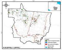


In this report Transparency in Forest Management in Mato Grosso we assess the logging situation in the State from August, 2010 to July, 2011. To do this we utilized information from the forest control systems at Sema (State Environmental Secretariat) in Mato Grosso: Simlam (Integrated System for Environmental Licensing and Monitoring) and Sisflora (System for Commercialization and Transportation of Forest Products). That information was also crossed with information generated by Simex (System for Monitoring Timber Harvesting), developed by Imazon.
Analysis of satellite images revealed that approximately 139,407 hectares of forests were logged from August, 2010 to July, 2011. Of that total, 73,953 hectares (53%) were authorized by Sema and 65,454 hectares (47%) were not authorized. Of the non-authorized total, the majority (64,852 or 99%) occurred in private, vacant or disputed areas and 602 hectares (1%) occurred in Protected Areas, land reform settlements and Conservation Units. When we compared logging numbers from the previous period (August, 2009 to July, 2010) with the recent one (August, 2010 to July, 2011), we observed that there was a 41% reduction (52,294 hectares) in the occurrence of authorized logging and 34% (34,346 hectares) in non-authorized logging.
In the areas logged with authorization, we assessed the situation of the respective Autex (Authorization for Timber Harvesting) issued in 2011 and verified that the great majority (98%) were regular. The remainder (2%) presented some degree of inconsistency, such as management authorized in a deforested area.
We also assessed the quality of timber harvesting between the two periods analyzed by using satellite images. We verified that the areas with good quality logging were reduced from 7 thousand hectares to 2 thousand hectares; the area with medium quality logging held steady at 38 thousand hectares; and the areas with low quality logging showed a notable reduction, from 80 thousand hectares to 34 thousand hectares.
Finally, we verified from satellite images that in 99% of the areas logged under forest management assessed from August, 2007 to July, 2011 the forest was maintained, while there was deforestation in only 1%.
Download the file here
This post was published on 14 de November de 2012
Several authors. System for Monitoring Timber Harvesting (Simex): Mapping of logging in the Brazilian Amazon…
Souza Jr, Carlos M; Marengo, José; Ferreira, Bruno; Ribeiro, Júlia; Schirmbeck, Lucimara W; Schirmbeck, Juliano;…
Several authors. System for Monitoring Timber Harvesting (Simex): Mapping logging in Amazonas State – August…
Several authors. System for Monitoring Timber Harvesting (Simex): Mapping logging in Roraima State – August…
Several authors. System for Monitoring Timber Harvesting (Simex): Mapping logging in Amapá State – August…
Several authors. System for Monitoring Timber Harvesting (Simex): Mapping logging in Pará State - August…