 Hayashi, S., Souza Jr, C., Sales, M. & Veríssimo, A.
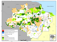
In December 2010, the Deforestation Alert System (SAD) detected 175 square kilometers of deforestation in the Legal Amazon. This represented a significant increase of 994% in relation to December 2009 when the deforestation totaled only 16 square kilometers. However, January 2011 registered an increase of 83 square kilometers of deforestation, which represented an increase of 22% in relation to January 2010 when the deforestation affected 68 square kilometers.
The accumulated deforestation between August 2010 and January 2011, corresponding to the first six months of the current deforestation calendar, totaled 858 square kilometers. There was a slight increase of 3% in relation to the same previous period (August 2009 to January 2010) when the deforestation totaled 836 square kilometers.
The degraded forests in the Legal Amazon totaled 541 square kilometers in December 2010. Compared to December 2009, when the degradation totaled 11 square kilometers, there was a highly significant increase of 4,818%. In relation to January 2011, the forest degradation affected 376 square kilometers. This represented an increase of 637% compared to January 2010 when the forest degradation was 51 square kilometers.
The accumulated forest degradation between August 2010 and January 2011 totaled 3,722 square kilometers. This represented a significant increase (338%) compared to the previous period (August 2009 to January 2010) when the forest degradation totaled 850 square kilometers.
The forest carbon affected by the deforestation between August 2010 and January 2011 (first six months of the current deforestation calendar) was 13.9 million tons, that is, about 51 million tons of CO2 equivalent. This represents a reduction of 5.2% in relation to the previous period (August 2009 to January 2010) when forest carbon affected by deforestation was about 47 million tons of C02 equivalent.
Through SAD it was only possible to monitor 30% of the forest area in the Legal Amazon in December 2010 and January 2011. The remaining 70% was covered by clouds, which made monitoring of the region difficult, especially in Amapá, Pará e Acre, which had over 80% of the forest area covered by clouds. Based on this, the deforestation and degradation data for November may be underestimated.
Download the file here
