 Hayashi, S., Souza Jr, C., Sales, M. & Veríssimo, A. 2011
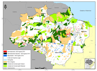
In February 2011, SAD detected 63 square kilometers of deforestation in the Legal Amazon. This represented a reduction of 28% in comparison to February 2010 when the deforestation totaled 87 square kilometers.
From August 2010 to February 2011 accumulated deforestation reached 925 square kilometers, similar to the previous period (August 2009 to February 2010), which was of 924 square kilometers.
In February 2011, most deforestation occurred in the states of Rondonia, 56 percent, and Para, 30 percent. The rest of deforestation occurred in the states of Mato Grosso, with 11 percent, and Roraima, 3 percent.
Degraded forests in Legal Amazon totaled 113 square kilometers in February 2011. Compared to February 2010, when degradation reached 99 square kilometers, it was an increase of 14 percent. Most forest degradation occurred in Rondonia (74 percent), far from Mato Grosso (15 percent), Para (7 percent), and Amazonas (4 percent).
Forest degradation accumulated from August 2010 to February 2011 totaled 3,836 square kilometers. Compared to the August 2009 to February 2010, it was a dramatic increase of 304 percent, when forest degradation reached 950 square kilometers.
In February 2011, deforestation as detected by SAD compromised some 4.7 million ton of CO2 equivalent, which represents a decrease of 18 percent when compared to February 2010. From August 2010 to February 2011, deforesting has compromised 56 million ton of CO2 equivalent, a reduction of 6.5 percent when compared to the period from August 2009 to February 2010, when forest carbon affected by deforesting was some 60 million ton of nCO2 equivalent.
SAD was able to monitor only 12 percent of the forest area in the Legal Amazon in February 2011. The remaining 88 percent was covered by clouds, which made difficult monitoring the region especially in the states of Acre, Amapa, Amazonas, Mato Grosso, and Para, which have more than 90 percent of their forest area obscured by clouds. For this reason, deforesting and degradation data in February may be underestimated.
Download the file here
