In July 2010, SAD detected 155 square kilometers of deforestation in the Legal Amazon. This represented a reduction of 71% in comparison to July 2009 when the deforestation totaled 532 square kilometers.
During the year (August 2009 to July 2010) the deforestation reached 1,488 square kilometers. In comparison to the previous period (August 2008 to July 2009) when the deforestation totaled 1,766 square kilometers, there was a reduction of 16%.
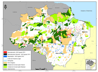
In July 2010, majority (51%) of the deforestation occurred in Pará, followed by Mato Grosso (23%), Rondônia (9%), Amazonas (8%), Acre (8%), and Tocantins (1%).
The accumulated deforestation from August 2009 to July 2010 resulted in a commitment of 95.6 million tons of C0 equivalents, which are subject to direct and future emissions by burning and decomposition. This represents a reduction of 20% in relation to the previous period (August 2008 to July 2009) when forest carbon affected by deforestation was about 121 million tons of C0 equivalent.
The degraded forests (forests intensely explored by wood and/or burning activities) in Legal Amazon totaled 159 square kilometers in July 2010. From this total, majority (57%) occurred in Pará, 32% in Mato Grosso, 5% in Rondônia, 3% in Acre, and 3% in Amazonas.
We analyzed the situation of 43 “critical deforestation municipalities. According to SAD, the deforestation of August 2009 to July 2010 in these municipalities was 631 square kilometers. If compared to the same previous period (August 2008 to July 2009), when the deforestation in these municipalities reached 1,033 square kilometers, there was a reduction of 40% in the deforestation.
In July 2010, it was possible to monitor 79% of the area with forest cover in the Legal Amazon. This bulletin also presents results of the SAD data check through flyovers in partnership with Greenpeace, and the field surveys conducted by technicians of the municipality of Paragominas.
Download the file here
This post was published on 13 de April de 2011
Imazon in Numbers - 5 research programs - 8 types of satellite image monitoring -…
Veríssimo, Beto; Brito, Brenda; Gandour, Clarissa; Santos, Daniel; Chiaveri, Joana; Assunção, Juliano; Lima, Manuele; Barreto,…
Various authors. System for Monitoring Timber Harvesting (Simex): Mapping logging in Mato Grosso state –…
Various authors. System for Monitoring Timber Harvesting (Simex): Mapping logging in Acre state – August…
Various authors. System for Monitoring Timber Harvesting (Simex): Mapping logging in Rondônia state – August…
Various authors. System for Monitoring Timber Harvesting (Simex): Mapping logging in Roraima state – August…