 Hayashi, S., Souza Jr, C., Sales, M. & Veríssimo, A. 2010.
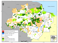
In March, 2010, the Deforestation Alert System (Sistema de Alerta de Desmatamento – SAD) recorded 76 square kilometers of deforestation in the Legal Amazon. That represents an increase of 35% in relation to March, 2009 when deforestation totaled 56 square kilometers.
The accumulated deforestation during the period of August, 2009 to March, 2010, corresponding to the first eight months of the current deforestation calendar, totaled 1000 square kilometers. In comparison with the previous period of August, 2008 to March, 2009, (when deforestation totaled 806 square kilometers), there was an increase of 24%.
In March, 2010, deforestation occurred mainly in Pará (45%) and in Mato Grosso (39%). The remainder occurred in Rondônia (6%), Roraima (4%), Acre (4%), Amazonas (1%) and Tocantins (1%).
The accumulated deforestation for the period of August, 2009 to March, 2010 resulted in the commitment of 65 million tons of CO2 equivalent subject to direct and future emissions due to burning events and decomposition. That represents a 34% increase in relation to the same previous period (August, 2008 to March, 2009) when the forest carbon affected by deforestation was around 48 million tons of equivalent CO2.
In March, 2010, the degraded forests (forests intensely exploited through logging activity and/or burning) in the Legal Amazon totaled 220 square kilometers. Of that total, the great majority (87%) occurred in Pará. In a smaller proportion, it occurred in Mato Grosso (11%), Rondônia (1%) and Tocantins (1%).
In March, 2010 it was possible to monitor only 37% of the area with cloud cover in the Legal Amazon, since 63% of the territory was covered by clouds (Figure 9). In March, 2009, cloud cover affected 66% of the territory.
Download the file here
