


| Título | A summary of research carried out under an ITTO Fellowship to evaluate the use of GIS for the planning of timber extraction in the eastern Amazon. |
| Autor | Carlos M. Souza Jr. |
| Ano de publicação | 1999 |
| Download |  |
Souza Jr., C. 1999. The potential of GIS application for the planning of timber extraction in the Brazilian Amazon. ITTO. Tropical Forest Update.
Resume
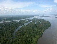
Over the past two decades, logging activity has spread widely in the Amazon. According to a survey conducted by IMAZON researchers in 19971998, there are 75 sawmill centres in operation in the Brazilian Amazon. Despite the potential economic and social advantages of planned forest management, logging has been practised in an unplanned fashion, causing serious environmental impacts. Several studies have shown that logging increases fire risk, causes soil compaction and tree damage, increases the risk of tree species extinction, contributes to carbon emission, and catalyses deforestation. IMAZON’s studies have shown that by applying forest management techniques the timber harvest cycle might be reduced from 90 years (unplanned extraction) to 30–40 years (planned extraction), and logging impacts can be reduced drastically as well. The profit margin in the planned operation also increases because of a significant reduction in log waste. However, to be effective, forest management requires information. This information includes data acquired during field inventories (i.e., tree location, species, tree quality, height and diameter, etc.) and data derived from the analysis of primary field data (felling angle, tree species distribution, road maps, etc.). The inventoried area ends up generating a large database that has both spatial (i.e., tree x and y coordinates) and tree descriptive information. This data needs to be input, stored, manipulated, analysed and retrieved in order to help in the planning of logging operations. These characteristics of the inventory database make the Geographic Information System (GIS) an appropriate tool to assist in such work. This research, carried out with the assistance of an ITTO Fellowship, investigated the potential of GIS application for the planning of timber extraction in the Brazilian Amazon, and evaluated the cost and time required to generate and to analyse maps with and without GIS.
This post was published on 22 de September de 1999
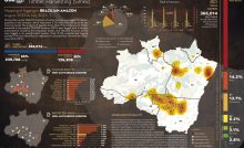
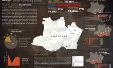
Several authors. System for Monitoring Timber Harvesting (Simex): Mapping of logging in the Brazilian Amazon…
Souza Jr, Carlos M; Marengo, José; Ferreira, Bruno; Ribeiro, Júlia; Schirmbeck, Lucimara W; Schirmbeck, Juliano;…
Several authors. System for Monitoring Timber Harvesting (Simex): Mapping logging in Amazonas State – August…
Several authors. System for Monitoring Timber Harvesting (Simex): Mapping logging in Roraima State – August…
Several authors. System for Monitoring Timber Harvesting (Simex): Mapping logging in Amapá State – August…
Several authors. System for Monitoring Timber Harvesting (Simex): Mapping logging in Pará State - August…