States with the most deforestation in January were Mato Grosso, Roraima and Pará

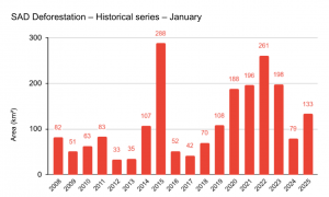
Deforestation in the Legal Amazon increased by 68% in January 2025 compared to the same period last year, reaching 133 km² of forest destruction. This is the sixth largest deforested area in the historical series for the month and represents more than 400 soccer fields devastated per day.

“These figures show growing pressure on the Amazon and serve as a warning sign of the need to strengthen monitoring efforts in the region. In order to reverse this scenario, it is essential to intensify inspection, expand operations to combat environmental crimes and promote policies that encourage the protection and sustainable use of the forest”, says Imazon researcher, Larissa Amorim.
The data is from Imazon’s Deforestation Alert System (SAD) and shows that Mato Grosso led the devastation in January this year, concentrating 45% of the total detected. Roraima (23%) and Pará (20%) follow, and together they account for 88% of the reduction in vegetation recorded in the Amazon.
As for the municipalities, six of the ten with the most deforestation are in Mato Grosso, two in Roraima and one in Pará.
|
Ranking |
Name | State | Area (km²) |
|
1 |
Amajari | Roraima | 12 |
|
2 |
Juína | Mato Grosso | 8 |
|
3 |
Uruará | Pará | 8 |
| 4 | Nova Maringá | Mato Grosso |
8 |
| 5 | Feliz Natal | Mato Grosso |
6 |
| 6 | Caracaraí | Roraima |
6 |
|
7 |
Porto dos Gaúchos | Mato Grosso | 5 |
|
8 |
Mucajaí | Roraima |
4 |
| 9 | Aripuanã | Mato Grosso |
4 |
| 10 | Tabaporã | Mato Grosso |
4 |
Researcher Larissa warns that, in addition to this growth, the loss of protected areas, concentrated in a few regions, is also a cause for concern. “One example is that, although Amazonas was the fifth most deforested state in January 2025, most of the conservation units with the most deforestation are located in this State”, she explains.
In addition, the study identified that seven of the ten indigenous lands most affected by deforestation are wholly or partially within Roraima, highlighting the vulnerability of indigenous lands in the State. ” The destruction of these lands has a direct impact on the indigenous peoples who depend on the forest for their survival, as well as compromising the maintenance of biodiversity of fauna and flora and climate regulation. Joint action by the relevant authorities is needed to tackle the most critical areas”, Larissa points out.
|
Ranking |
Name | State |
Area (km²) |
|
1 |
TI Yanomami | Amazonas/Roraima | 0.2 |
|
2 |
TI Bacurizinho | Maranhão | 0.2 |
| 3 | TI Alto Rio Negro | Amazonas/Roraima |
0.08 |
|
4 |
TI Malacacheta | Roraima | 0.05 |
|
5 |
TI Japuíra | Mato Grosso |
0.04 |
| 6 | TI Canauanim | Roraima |
0.04 |
|
7 |
TI Jurubaxi-Téa | Amazonas/Roraima | 0.02 |
|
8 |
TI Manoá/Pium | Roraima |
0.02 |
| 9 | TI Raimundão | Roraima |
0.02 |
| 10 | TI WaiWái | Roraima |
0.02 |
Forest degradation in January is the third highest since 2009
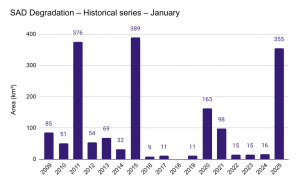
Degradation, characterized by the partial clearing of vegetation due to fires and logging, reached 355 km² in the first month of 2025, affecting a territory larger than the city of Belo Horizonte, the capital of Minas Gerais State. The area is still 21 times larger than that affected in the same period last year, when 16 km² were affected. The figure is the third highest in the historical series for the month, trailing only January 2015 (389 km²) and 2011 (376 km²).

The states in the Amazon with the highest incidence of this activity were Pará (46%), with 116 km² degraded, and Maranhão (40%), with 144 km². Together they concentrated 86% of the degraded areas.
They are also home to the ten municipalities with the most degradation, five of them in Pará and five in Maranhão. At the top of the ranking is Prainha, located in the north of Pará, which had 67 km², equivalent to 6,700 soccer fields, of forests affected.
|
Ranking |
Name | State |
Area (km²) |
|
1 |
Prainha | Pará | 67 |
|
2 |
Bom Jardim | Maranhão | 58 |
| 3 | Centro Novo do Maranhão | Maranhão |
52 |
| 4 | Almeirim | Pará |
38 |
|
5 |
Mojuí dos Campos | Pará | 26 |
|
6 |
Santana do Araguaia | Pará |
15 |
| 7 | Zé Doca | Maranhão |
14 |
|
8 |
Amarante do Maranhão | Maranhão | 10 |
|
9 |
Centro do Guilherme | Maranhão |
9 |
| 10 | Monte Alegre | Pará |
7 |
In January, eight Amazon Conservation Units were found to be affected by degradation. Three of them are located in Pará, one in Maranhão, two in Rondônia, one in Amapá and one in Amazonas, Mato Grosso and Roraima, namely: Rebio do Gurupi (50 km²), FES do Paru (17 km²), APA Arquipélago do Marajó (2 km²), Parna Serra da Cutia (2 km²), Parna dos Campos Amazônicos (1 km²), Resex do Rio Cajari (1 km²), APA do Tapajós (0.3 km²) and Resex do Rio Pacaás Novos (0.2 km²).
In addition to the Conservation Units, seven Indigenous Lands were also degraded, three of them in Maranhão, two in Mato Grosso, one in Amazonas and one in Pará. At the top of the ranking was the Alto Turiaçu Indigenous Land, located in Maranhão, which had 69 km² affected, equivalent to 6,900 soccer fields of degraded forest in the first month of the year.
|
Ranking |
Name | State |
Area (km²) |
|
1 |
TI Alto Turiaçu | Maranhão | 69 |
|
2 |
TI Araribóia | Maranhão |
10 |
| 3 | TI Piripkura | Mato Grosso |
2 |
|
4 |
TI Cunhã-Sapucaia | Amazonas | 1 |
|
5 |
TI Alto Rio Guamá | Pará | 0.4 |
| 6 | TI Wawi | Mato Grosso |
0.1 |
| 7 | TI Awá | Maranhão |
0.08 |
“Despite the increase, deforestation and degradation figures are expected to reduce in the coming months, as we are in the months where historically these disturbances are not so intense due to the rains. That’s why it is important that the government and relevant agencies use this time to focus even more on preventive actions and planning to contain the impacts before the most critical period begins”, warns Carlos Souza Jr., a researcher with Imazon.
See January’s data here
Access all the deforestation and degradation bulletins here
Learn more about SAD here
