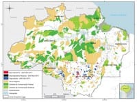
 Check the data on deforestation and forest degradation in the Amazon in January 2012.
S. Hayashi, C. Souza Jr., M. Sales, A. Veríssimo, Forest Transparency for the Brazilian Amazon January 2012, Imazon (2012).
In December 2012, most part (88 %) of the forest area of the Brazilian Amazon was covered by clouds. This compromised the detection of the deforestation and forest degradation for this month through the images of the MODIS used by SAD. Only 33 km² of deforestation were detected in the Brazilian Amazon under these conditions.
Pará led with 45% of the 33 km² of deforestation detected in January 2012, followed by Rondônia (33%), Mato Grosso (12%), Amazonas (9%) and Acre (1%).
The deforestation accumulated in the period of August 2011 to January 2012, corresponding to the first six months of the current Deforestation Calendar, has reached 600 square kilometers. There was 30% reduction regarding the same previous period (August 2010 to January 2011) when the deforestation totaled 856 square kilometers.
The degraded forests in the Brazilian Amazon totaled 54 square kilometers in January 2012. Pará was responsible for 50]5 of the forest degradation followed by Mato Grosso (42%), Rondônia (7%) and Amazonas (1%).
The forest degradation accumulated in the period of August 2011 to January 2012 totaled 1.433 square kilometers. Regarding the previous period (August 2010 to January 2011) there was a reduction of 61%, when the forest degradation totaled 3.700 square kilometers.
In January 2012, the deforestation detected by SAD compromised 3.2 million tons of equivalent CO2. In the accumulated period (August 2011 – January 2012) the emissions of equivalent CO2 related to the deforestation totaled 40 million tons which represents a reduction of 38% regarding the previous period (August 2010 to January 2011).
Download the file here
