


| Título | Mapping land use of tropical regions from space. |
| Autores | Carlos Souza Jr. Carlos M. |
| Ano de publicação | 2006 |
| DOI | https://doi.org/10.1073/pnas.0606804103 |
Souza Jr., C. 2006. Mapping land use of tropical regions from space. Proceedings of the National Academy of Science 103 (39): 1461-1462.
This is a commentary on Morton et al article “Cropland expansion changes deforestation dynamics in the southern Brazilian Amazon. Besides the comments, it presents a forest monitoring program that integrates de approach developed by Morton et al with other techniques and tools already developed. It also indicates future research activities and land-use policy applications that will be facilitated by the remote-sensing techniques developed by Morton et al : a) improving carbon flux models; b) licensing, command control, and law enforcement; c) agribusiness market regulation, and d) modeling deforestation dynamics.
This post was published on 19 de September de 2006
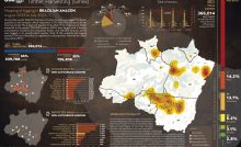
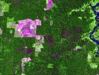
Several authors. System for Monitoring Timber Harvesting (Simex): Mapping of logging in the Brazilian Amazon…
Souza Jr, Carlos M; Marengo, José; Ferreira, Bruno; Ribeiro, Júlia; Schirmbeck, Lucimara W; Schirmbeck, Juliano;…
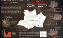
Several authors. System for Monitoring Timber Harvesting (Simex): Mapping logging in Amazonas State – August…
Several authors. System for Monitoring Timber Harvesting (Simex): Mapping logging in Roraima State – August…
Several authors. System for Monitoring Timber Harvesting (Simex): Mapping logging in Amapá State – August…
Several authors. System for Monitoring Timber Harvesting (Simex): Mapping logging in Pará State - August…