Saraiva, Marciano; Protas, Églen; Salgado, Moisés; Souza; Carlos. Automatic Mapping of Center Pivot Irrigation Systems from Satellite Images Using Deep Learning. Remote Sensing, 7 February 2020. https://doi.org/10.3390/rs12030558
Abstract: The availability of freshwater is becoming a global concern. Because agricultural consumption has been increasing steadily, the mapping of irrigated areas is key for supporting the monitoring of land use and better management of available water resources. In this paper, we propose a method to automatically detect and map center pivot irrigation systems using U-Net, an image segmentation convolutional neural network architecture, applied to a constellation of PlanetScope images from the Cerrado biome of Brazil. Our objective is to provide a fast and accurate alternative to map center pivot irrigation systems with very high spatial and temporal resolution imagery. We implemented a modified U-Net architecture using the TensorFlow library and trained it on the Google cloud platform with a dataset built from more than 42,000 very high spatial resolution PlanetScope images acquired between August 2017 and November 2018. The U-Net implementation achieved a precision of 99% and a recall of 88% to detect and map center pivot irrigation systems in our study area. This method, proposed to detect and map center pivot irrigation systems, has the potential to be scaled to larger areas and improve the monitoring of freshwater use by agricultural activities.
This post was published on 7 de fevereiro de 2020
Amorim, L., Ferreira, R., Dias, M., Souza Jr., C., & Veríssimo, A. Sistema de Alerta…

Título Índice de Progresso Social Brasil 2025 Autores Melissa Wilm Daniel Santos Beto Veríssimo Marcelo…
Amorim, L., Ferreira, R., Dias, M., Souza Jr., C., & Veríssimo, A. Sistema de Alerta…
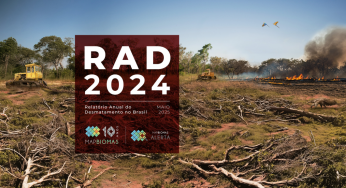
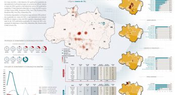
Título Relatório Anual do Desmatamento no Brasil - RAD2024 Autores Carolina Del Lama Julia Shimbo…

Título Fatos da Amazônia 2025 Autores Daniel Santos Manuele Lima Agatha Vilhena Beto Veríssimo Caíque…
Amorim, L., Ferreira, R., Dias, M., Souza Jr., C., & Veríssimo, A. Sistema de Alerta…