Combining spectral and spatial information to map canopy damage from selective logging and forest fires

facebook - Combining spectral and spatial information to map canopy damage from selective logging and forest firesfacebook - Combining spectral and spatial information to map canopy damage from selective logging and forest fireslinkedin - Combining spectral and spatial information to map canopy damage from selective logging and forest fireslinkedin - Combining spectral and spatial information to map canopy damage from selective logging and forest fireswhatsapp - Combining spectral and spatial information to map canopy damage from selective logging and forest fireswhatsapp - Combining spectral and spatial information to map canopy damage from selective logging and forest firesx - Combining spectral and spatial information to map canopy damage from selective logging and forest firesx - Combining spectral and spatial information to map canopy damage from selective logging and forest firesa2a - Combining spectral and spatial information to map canopy damage from selective logging and forest firesa2a - Combining spectral and spatial information to map canopy damage from selective logging and forest fires

Souza Jr., Carlos M.; Roberts, Dar A.; Cochrane, Mark A. Combining spectral and spatial information to map canopy damage from selective logging and forest fires. Remote Sensing of Environment Volume 98, Issues 2–3, 15 October 2005, Pages 329-343. DOI:10.1016/j.rse.2005.07.013

Abstract: 
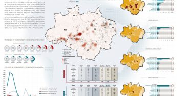
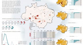
We propose a new spectral index, the Normalized Difference Fraction Index (NDFI), for enhanced detection of forest canopy damage caused by selective logging activities and associated forest fires. The NDFI synthesizes information from several component fraction images derived from spectral mixture models. Interpretation of the NDFI data is facilitated by a contextual classification algorithm (CCA) that enables accurate mapping of logging and fire-derived canopy damages. The CCA utilizes detected log landings, which are the spatial signature of selective logging, as starting locations for searching the NDFI image for canopy damage. This process separates canopy changes due to logging and associated forest fires from those caused by other natural disturbances. These methods were tested in the Sinop region, in the Southern Brazilian Amazon. Forest transect inventories, conducted along a gradient of degraded forests, were used to evaluated the performance of the NDFI. The NDFI was more sensitive to canopy damage than any individual fraction and is shown to have the potential for further sub-classification of degradation levels in forest environments. Map accuracy of forest canopy damage using the CCA classifier, assessed with aerial videography images, was 94%. The proposed NDFI-CCA classifier approach can be fully automated and, therefore, holds great promise as a forest monitoring tool in tropical forests.

Download

facebook - Combining spectral and spatial information to map canopy damage from selective logging and forest firesfacebook - Combining spectral and spatial information to map canopy damage from selective logging and forest fireslinkedin - Combining spectral and spatial information to map canopy damage from selective logging and forest fireslinkedin - Combining spectral and spatial information to map canopy damage from selective logging and forest fireswhatsapp - Combining spectral and spatial information to map canopy damage from selective logging and forest fireswhatsapp - Combining spectral and spatial information to map canopy damage from selective logging and forest firesx - Combining spectral and spatial information to map canopy damage from selective logging and forest firesx - Combining spectral and spatial information to map canopy damage from selective logging and forest firesa2a - Combining spectral and spatial information to map canopy damage from selective logging and forest firesa2a - Combining spectral and spatial information to map canopy damage from selective logging and forest fires

This post was published on 15 de outubro de 2005

AddThis Website Tools

Notícias recentes

Fatos da Amazônia 2025Fatos da Amazônia 2025

Fatos da Amazônia 2025

Título Fatos da Amazônia 2025 Autores Daniel Santos Manuele Lima Agatha Vilhena Beto Veríssimo Caíque…

30 de abril de 2025
Sistema de Alerta de Desmatamento (SAD) – Março de 2025Sistema de Alerta de Desmatamento (SAD) – Março de 2025

Sistema de Alerta de Desmatamento (SAD) – Março de 2025

Amorim, L., Ferreira, R., Dias, M., Souza Jr., C., & Veríssimo, A. Sistema de Alerta…

25 de abril de 2025
A Vocação da Restauração Florestal na Amazônia com Base na Vegetação SecundáriaA Vocação da Restauração Florestal na Amazônia com Base na Vegetação Secundária

A Vocação da Restauração Florestal na Amazônia com Base na Vegetação Secundária

Título A Vocação da Restauração Florestal na Amazônia com Base na Vegetação Secundária Autores Jayne…

30 de março de 2025
Sistema de Alerta de Desmatamento (SAD) – Fevereiro de 2025Sistema de Alerta de Desmatamento (SAD) – Fevereiro de 2025

Sistema de Alerta de Desmatamento (SAD) – Fevereiro de 2025

Amorim, L., Ferreira, R., Dias, M., Souza Jr., C., & Veríssimo, A. Sistema de Alerta…

27 de março de 2025
Lições da Expansão da Pecuária Bovina no Brasil (2000-2023) para uma Produção Sustentável e EficienteLições da Expansão da Pecuária Bovina no Brasil (2000-2023) para uma Produção Sustentável e Eficiente

Lições da Expansão da Pecuária Bovina no Brasil (2000-2023) para uma Produção Sustentável e Eficiente

Título Lições da Expansão da Pecuária Bovina no Brasil (2000-2023) para uma Produção Sustentável e…

13 de março de 2025
Explosive growth of secondary roads is linked to widespread tropical deforestationExplosive growth of secondary roads is linked to widespread tropical deforestation

Explosive growth of secondary roads is linked to widespread tropical deforestation

Título Explosive growth of secondary roads is linked to widespread tropical deforestation Autores Jayden E.…

7 de março de 2025