Sales, Marcio H. R.; Bruin, Sytze de; Souza, Carlos; Herold, Martin. Land Use and Land Cover Area Estimates From Class Membership Probability of a Random Forest Classification. IEEE Transactions on Geoscience and Remote Sensing, Volume 60, 09 June 2021. DOI: 10.1109/TGRS.2021.3080083
Abstract: Estimates of the area of land cover classes or land change are frequently calculated from land cover classification maps by counting the pixels labeled as each class in the map. This procedure is known to produce biased estimates of area for many widely used classification algorithms, including random forests. Poststratification estimation using the mapped classes as strata has been proposed to obtain unbiased estimates of the class areas. Still, the method requires additional sampling units, which may not be available or be the most efficient method depending on the application. Alternatively, consistent estimates of class areas can be obtained using class membership probabilities estimates from a random forest classification. This article demonstrates that, for a large sample and proper set of explanatory variables, the error of the predicted class membership probabilities obtained from a random forest classification converges to zero. Therefore, the expected class areas calculated from these probabilities converge to the population class areas. On average, the relative error of the expected class proportions computed by class membership probabilities from a random forests model was 40% points lower than the proportions estimated by pixel counting. Our proposed approach is also comparable to the area-adjusted method, which is currently considered the best practice by the remote sensing community. We recommend that class probability estimates area always retained and used for calculating expected class areas or area proportions based on our results. Our method reduces bias compared to statistics calculated by pixel counting and circumvents the need for poststratification area estimates under certain conditions.
This post was published on 9 de junho de 2021
Amorim, L., Ferreira, R., Dias, M., Souza Jr., C., & Veríssimo, A. Sistema de Alerta…

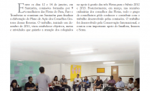
Título Índice de Progresso Social Brasil 2025 Autores Melissa Wilm Daniel Santos Beto Veríssimo Marcelo…
Amorim, L., Ferreira, R., Dias, M., Souza Jr., C., & Veríssimo, A. Sistema de Alerta…
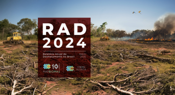
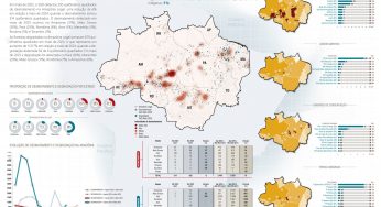
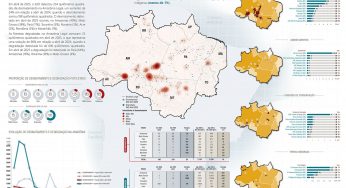
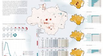
Título Relatório Anual do Desmatamento no Brasil - RAD2024 Autores Carolina Del Lama Julia Shimbo…

Título Fatos da Amazônia 2025 Autores Daniel Santos Manuele Lima Agatha Vilhena Beto Veríssimo Caíque…
Amorim, L., Ferreira, R., Dias, M., Souza Jr., C., & Veríssimo, A. Sistema de Alerta…