Botelho, J., Jr.; Costa, S.C.P.; Ribeiro, J.G.; Souza, C.M., Jr. Mapping Roads in the Brazilian Amazon with Artificial Intelligence and Sentinel-2. Remote Sens. 2022, 14, 3625. https://doi.org/10.3390/
rs14153625
Abstract: This study presents our efforts to automate the detection of unofficial roads (herein, roads) in the Brazilian Amazon using artificial intelligence (AI). In this region, roads are built by loggers, goldminers, and unauthorized land settlements from existing official roads, expanding over pristine forests and leading to new deforestation and fire hotspots. Previous research used visual interpretation, hand digitization, and vector editing techniques to create a thorough Amazon Road Dataset (ARD) from Landsat imagery. The ARD allowed assessment of the road dynamics and impacts on deforestation, landscape fragmentation, and fires and supported several scientific and societal applications. This research used the existing ARD to train and model a modified U-Net algorithm to detect rural roads in the Brazilian Amazon using Sentinel-2 imagery from 2020 in the Azure Planetary Computer platform. Moreover, we implemented a post-AI detection protocol to connect and vectorize the U-Net road detected to create a new ARD.We estimated the recall and precision accuracy using an independent ARD dataset, obtaining 65% and 71%, respectively. Visual interpretation of the road detected with the AI algorithm suggests that the accuracy is underestimated. The reference dataset does not include all roads that the AI algorithm can detect in the Sentinel-2 imagery. We found an astonishing footprint of roads in the Brazilian Legal Amazon, with 3.46 million km of roads mapped in 2020. Most roads are in private lands (~55%) and 25% are in open public lands under land grabbing pressure. The roads are also expanding over forested areas with 41% cut or within 10 km from the roads, leaving 59% of the 3.1 million km2 of the remaining original forest roadless. Our AI and post-AI models fully automated road detection in rural areas of the Brazilian Amazon, making it possible to operationalize road monitoring. We are using the AI road map to understand better rural roads’ impact on new deforestation, fires, and landscape fragmentation and to support societal and policy applications for forest conservation and regional planning.
This post was published on 28 de julho de 2022
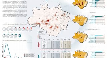
Amorim, L., Ferreira, R., Dias, M., Souza Jr., C., & Veríssimo, A. Sistema de Alerta…
Título Índice de Progresso Social Brasil 2025 Autores Melissa Wilm Daniel Santos Beto Veríssimo Marcelo…
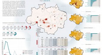
Amorim, L., Ferreira, R., Dias, M., Souza Jr., C., & Veríssimo, A. Sistema de Alerta…
Título Relatório Anual do Desmatamento no Brasil - RAD2024 Autores Carolina Del Lama Julia Shimbo…
Título Fatos da Amazônia 2025 Autores Daniel Santos Manuele Lima Agatha Vilhena Beto Veríssimo Caíque…
Amorim, L., Ferreira, R., Dias, M., Souza Jr., C., & Veríssimo, A. Sistema de Alerta…