Turpo Cayo, E.Y.; Borja, M.O.; Espinoza-Villar, R.; Moreno, N.; Camargo, R.; Almeida, C.; Hopfgartner, K.; Yarleque, C.; Souza, C.M., Jr. Mapping Three Decades of Changes in the Tropical Andean Glaciers Using Landsat Data Processed in the Earth Engine. Remote Sens. 2022, 14, 1974. https:// doi.org/10.3390/rs14091974
Abstract: The fast retreat of the tropical Andean glaciers (TAGs) is considered an important indicator of climate change impact on the tropics, since the TAGs provide resources to highly vulnerable mountain populations. This study aims to reconstruct the glacier coverage of the TAGs, using Landsat time-series images from 1985 to 2020, by digitally processing and classifying satellite images in the Google Earth Engine platform. We used annual reductions of the Normalized Difference Snow Index (NDSI) and spectral bands to capture the pixels with minimum snow cover. We also implemented temporal and spatial filters to have comparable maps at a multitemporal level and reduce noise and temporal inconsistencies. The results of the multitemporal analysis of this study confirm the recent and dramatic recession of the TAGs in the last three decades, in base to physical and statistical significance. The TAGs reduced from 2429.38 km2 to 1409.11 km2 between 1990 and 2020, representing a loss of 42% of the total glacier area. In addition, the time-series analysis showed more significant losses at altitudes below 5000 masl, and differentiated changes by slope, latitude, and longitude. We found a more significant percentage loss of glacier areas in countries with less coverage. The multiannual validation showed accuracy values of 92.81%, 96.32%, 90.32%, 97.56%, and 88.54% for the metrics F1 score, accuracy, kappa, precision, and recall, respectively. The results are an essential contribution to understanding the TAGs and guiding policies to mitigate climate change and the potential negative impact of freshwater shortage on the inhabitants and food production in the Andean region.
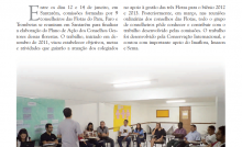
This post was published on 22 de abril de 2022
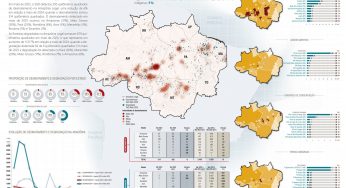
Amorim, L., Ferreira, R., Dias, M., Souza Jr., C., & Veríssimo, A. Sistema de Alerta…

Título Índice de Progresso Social Brasil 2025 Autores Melissa Wilm Daniel Santos Beto Veríssimo Marcelo…
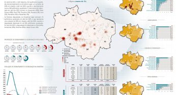
Amorim, L., Ferreira, R., Dias, M., Souza Jr., C., & Veríssimo, A. Sistema de Alerta…
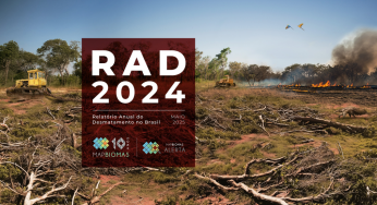
Título Relatório Anual do Desmatamento no Brasil - RAD2024 Autores Carolina Del Lama Julia Shimbo…

Título Fatos da Amazônia 2025 Autores Daniel Santos Manuele Lima Agatha Vilhena Beto Veríssimo Caíque…
Amorim, L., Ferreira, R., Dias, M., Souza Jr., C., & Veríssimo, A. Sistema de Alerta…