


Various authors. System for Monitoring Timber Harvesting (Simex): Mapping logging in Amazonas state – August 2021 to July 2022. Belém: Imazon, Idesam, Imaflora e ICV.
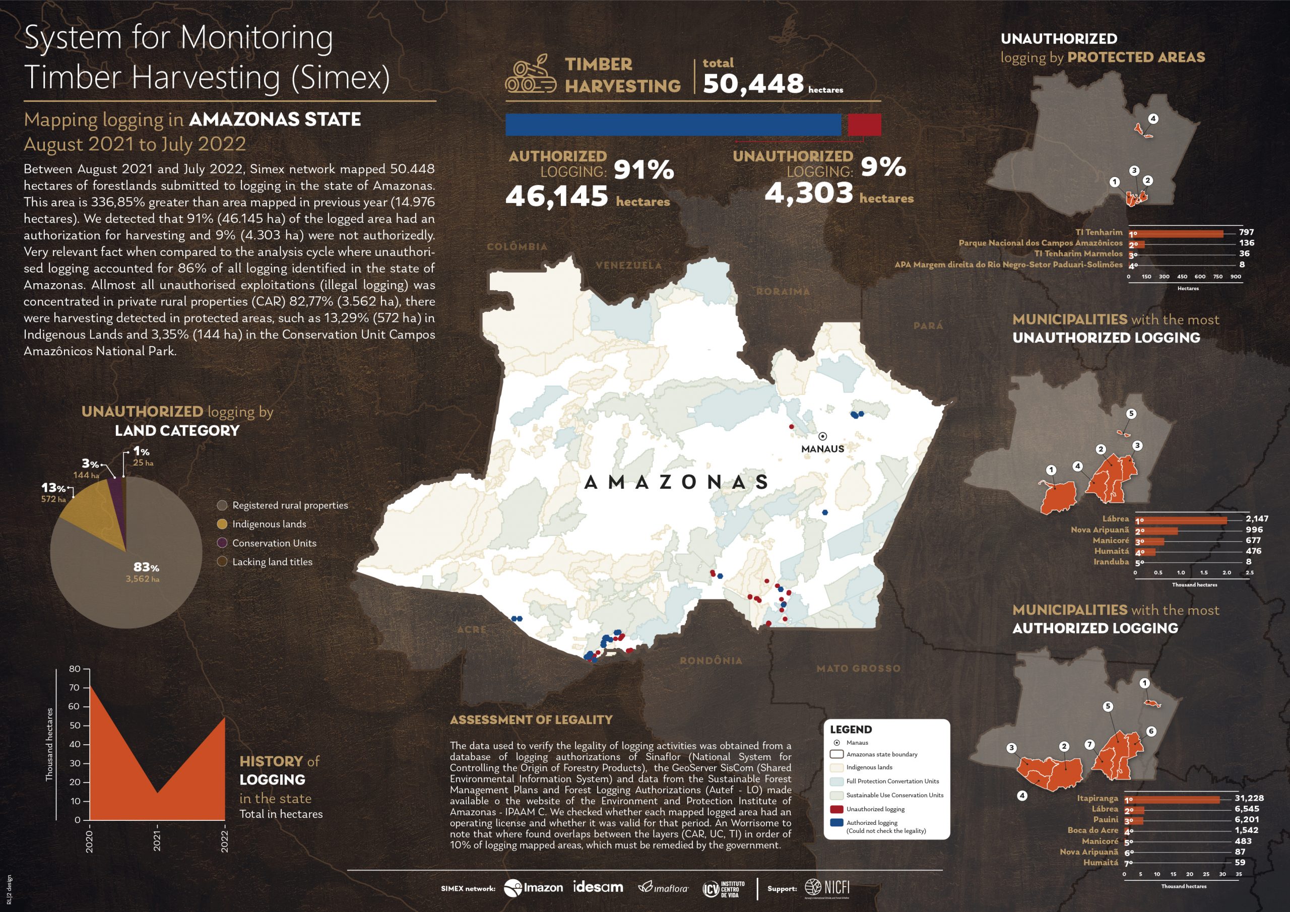
Between August 2021 and July 2022, Simex network mapped 50.448 hectares of forestlands submitted to logging in the state of Amazonas.
This area is 336,85% greater than area mapped in previous year (14.976 hectares). We detected that 91% (46.145 ha) of the logged area had an
authorization for harvesting and 9% (4.303 ha) were not authorizedly. Very relevant fact when compared to the analysis cycle where unauthorised logging accounted for 86% of all logging identified in the state of Amazonas. Allmost all unauthorised exploitations (illegal logging) was concentrated in private rural properties (CAR) 82,77% (3.562 ha), there were harvesting detected in protected areas, such as 13,29% (572 ha) in Indigenous Lands and 3,35% (144 ha) in the Conservation Unit Campos Amazônicos National Park.
ASSESSMENT OF LEGALITY
The data used to verify the legality of logging activities was obtained from a database of logging authorizations of Sinaflor (National System for Controlling the Origin of Forestry Products), the GeoServer SisCom (Shared Environmental Information System) and data from the Sustainable Forest Management Plans and Forest Logging Authorizations (Autef – LO) made available o the website of the Environment and Protection Institute of Amazonas – IPAAM C. We checked whether each mapped logged area had an operating license and whether it was valid for that period. An Worrisome to note that where found overlaps between the layers (CAR, UC, TI) in order of 10% of logging mapped areas, which must be remedied by the government.
This post was published on 14 de dezembro de 2023
Amorim, L., Ferreira, R., Dias, M., Souza Jr., C., & Veríssimo, A. Sistema de Alerta…
Título Índice de Progresso Social Brasil 2025 Autores Melissa Wilm Daniel Santos Beto Veríssimo Marcelo…
Amorim, L., Ferreira, R., Dias, M., Souza Jr., C., & Veríssimo, A. Sistema de Alerta…
Título Relatório Anual do Desmatamento no Brasil - RAD2024 Autores Carolina Del Lama Julia Shimbo…
Título Fatos da Amazônia 2025 Autores Daniel Santos Manuele Lima Agatha Vilhena Beto Veríssimo Caíque…
Amorim, L., Ferreira, R., Dias, M., Souza Jr., C., & Veríssimo, A. Sistema de Alerta…