


Various authors. System for Monitoring Timber Harvesting (Simex): Mapping logging in Rondônia state – August 2021 to July 2022. Belém: Imazon, Idesam, Imaflora e ICV.
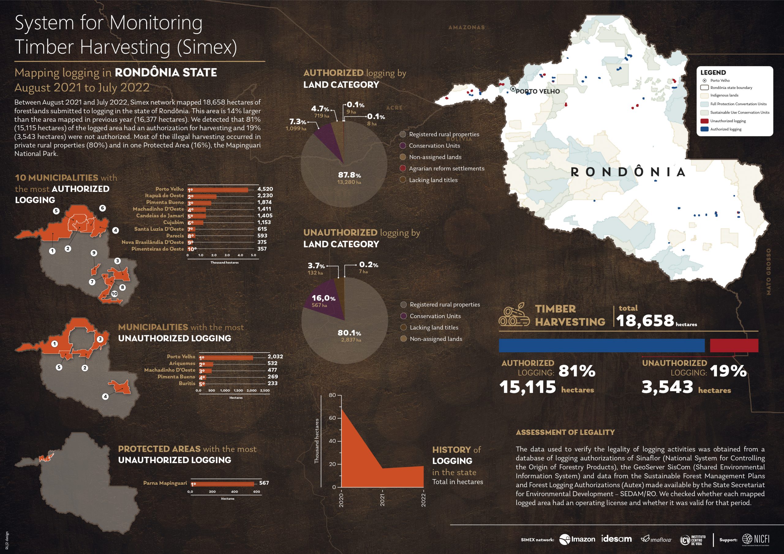
Between August 2021 and July 2022, Simex network mapped 18,658 hectares of forestlands submitted to logging in the state of Rondônia. This area is 14% larger than the area mapped in previous year (16,377 hectares). We detected that 81% (15,115 hectares) of the logged area had an authorization for harvesting and 19% (3,543 hectares) were not authorized. Most of the illegal harvesting occurred in private rural properties (80%) and in one Protected Area (16%), the Mapinguari National Park.
ASSESSMENT OF LEGALITY
The data used to verify the legality of logging activities was obtained from a database of logging authorizations of Sinaflor (National System for Controlling the Origin of Forestry Products), the GeoServer SisCom (Shared Environmental Information System) and data from the Sustainable Forest Management Plans and Forest Logging Authorizations (Autex) made available by the State Secretariat for Environmental Development – SEDAM/RO. We checked whether each mapped logged area had an operating license and whether it was valid for that period.
This post was published on 15 de dezembro de 2023
Amorim, L., Ferreira, R., Dias, M., Souza Jr., C., & Veríssimo, A. Sistema de Alerta…
Título Índice de Progresso Social Brasil 2025 Autores Melissa Wilm Daniel Santos Beto Veríssimo Marcelo…
Amorim, L., Ferreira, R., Dias, M., Souza Jr., C., & Veríssimo, A. Sistema de Alerta…
Título Relatório Anual do Desmatamento no Brasil - RAD2024 Autores Carolina Del Lama Julia Shimbo…
Título Fatos da Amazônia 2025 Autores Daniel Santos Manuele Lima Agatha Vilhena Beto Veríssimo Caíque…
Amorim, L., Ferreira, R., Dias, M., Souza Jr., C., & Veríssimo, A. Sistema de Alerta…