Arevalo, Paulo A.; Stanimirova, Radost; Zhang, Yingtong; McAvoy, Kristina; Tarrio, Katelyn; Stonebrook, Sophia; Hu, Kai-Ting; Friedl, Mark A.; Woodcock, Curtis E.; Zhu, Zhe; Barber, Christopher; Bullock, Eric; Gorelick, Noel; Turlej, Konrad; Olofsson, Pontus; Wang, Jonathan A.; Souza, Carlos M. Update on the Moderate Spatial Resolution Mapping of Global Land Cover and Land Cover Change Across Multiple Decades from Landsat. AGU Fall Meeting 2023, held in San Francisco, CA, 11-15 December 2023, Session: Biogeosciences/Science and Applications Enabled by Remote Sensing Data Fusion and Time Series Analysis I Oral, id. B52C-02. Bibcode: 2023AGUFM.B52C..02A.
Land cover maps are widely used for basic and applied research on Earth’s biophysical, ecological, and socio-economic systems. Multiple initiatives have produced global land cover maps for recent years using diverse methodologies applied to Sentinel-2 imagery. These products include the WorldCover product by the European Space Agency, ESRI’s land use and land cover product and Google’s Dynamic World. As the speed and intensity of global environmental change continues to increase, accurate data representing global land cover change is essential. To address the need for high-quality multi-temporal land cover change data, the Global Land Cover mapping and Estimation (GLanCE) project is generating annual maps of global land cover and land cover change between the years 2001 to 2020 at 30 m spatial resolution. To achieve this, we apply the Continuous Change Detection and Classification algorithm (CCDC) on the global record of Landsat observations to derive time segments separated by breakpoints representing disturbances. Those segments can be used to reconstruct the land change history, in the form of periods of stable and transitional land cover. Features derived from the time segments, along with ancillary data and a large training dataset, are input into a classification workflow that generates annual land cover and land cover change data, as well as other derived science products. Here we provide an overview of the methods used for extracting the classification features, for training and applying regionalized classifiers, and for post-processing the results to obtain discreet annual maps. We describe current and upcoming approaches to handle segments representing transitional land cover states, and to address the omission of important changes such as forest loss. We present a summary of current results and provide an update on incoming datasets, focusing on South America and Oceania. We also discuss an upcoming public Google Earth Engine catalog to host up to date versions of our datasets, and approaches to extend their temporal coverage.
This post was published on 11 de dezembro de 2023
Título Índice de Progresso Social Brasil 2025 Autores Melissa Wilm Daniel Santos Beto Veríssimo Marcelo…
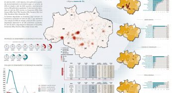
Amorim, L., Ferreira, R., Dias, M., Souza Jr., C., & Veríssimo, A. Sistema de Alerta…

Título Fatos da Amazônia 2025 Autores Daniel Santos Manuele Lima Agatha Vilhena Beto Veríssimo Caíque…
Amorim, L., Ferreira, R., Dias, M., Souza Jr., C., & Veríssimo, A. Sistema de Alerta…
Título A Vocação da Restauração Florestal na Amazônia com Base na Vegetação Secundária Autores Jayne…
Amorim, L., Ferreira, R., Dias, M., Souza Jr., C., & Veríssimo, A. Sistema de Alerta…